19 Days | Maximum Altitude: 5,416m. | Moderate to Challenging
Introduction
The Annapurna Conservation Area is the largest protected region in Nepal and the Annapurna Circuit passes through the full breadth of it. This trek is celebrated not just for its mountain scenery but for the extraordinary variety of everything it offers. You begin your trek in the humid subtropical lowlands of the Marsyangdi valley, trek through the terraced rice fields and villages of Lamjung district, climb into the high semi-arid landscape of the Manang valley, and cross the Thorong La Pass at 5,416 meters, one of the highest trekking passes in the world. On the far side everything changes. You descend into the ancient Tibetan-influenced world of upper Mustang, where eroded cliffs, cave dwellings, and whitewashed chortens line a landscape that looks and feels completely different from anything you have trekked through to reach it.l
The people of this route are as varied as the terrain. In the lower valleys you pass through communities of the Gurung, Magar, and Brahmin people. As you gain altitude, the villages become increasingly Tibetan Buddhist in character. Manang and the villages of upper Mustang follow Tibetan customs, speak Tibetan dialects, and maintain a culture that has changed very little over centuries. The Muktinath temple is one of the most sacred sites in both Hindu and Buddhist traditions. Pilgrims travel from all over Nepal and India to worship here. The beautiful mountains seen from the circuit include Annapurna I at 8,091 meters, Dhaulagiri at 8,167 meters, Manaslu at 8,163 meters, Machhapuchhre, Nilgiri, Gangapurna, Tilicho, and the full Annapurna massif.
This 18-day route adds the beautiful lower Mustang valleys, the natural hot springs of Tatopani, the rhododendron forests above Ghorepani, and the legendary Poon Hill sunrise before descending through the Gurung village of Ghandruk to Pokhara.
Trip Details
Duration: 18 Days
Maximum Altitude: 5,416 m (Thorong La Pass)
Difficulty Level: Moderate to Challenging
Best Season: March to May and September to November
Start Point: Kathmandu
End Point: Pokhara to Kathmandu
Trek Style: Tea House Trek
Average Walking Hours: 5 to 8 hours per day
Trek Region: Annapurna Conservation Area, Gandaki Province
Major Highlights
• Crossing Thorong La Pass: At 5,416 meters, the Thorong La is one of the highest trekking passes in the world. Crossing it from High Camp in the early morning, reaching the prayer flags at the top, and descending into the completely different world of upper Mustang is the single most dramatic day on any Nepal trekking route.
• Muktinath, Marpha, and the Mustang Valleys: The sacred Muktinath temple, the ancient walled town of Kagbeni, and the beautiful whitewashed apple orchards of Marpha give this extended route a cultural depth that the standard circuit finish in Jomsom cannot match. Adding Tatopani hot springs and the Poon Hill sunrise creates a complete journey through the best of the Annapurna region.
• Poon Hill Sunrise: Standing on Poon Hill at 3,210 meters as the sun comes up over the eastern Himalayan horizon and lights up the Annapurna range, Dhaulagiri, and Machhapuchhre one by one is one of the most celebrated sunrise experiences in all of Nepal. It is a fitting final morning on the mountain section of this trek.
Brief Itinerary
Day
Route
Elevation
Overnight
1
Arrival in Kathmandu
1,400 m
Kathmandu
2
Briefing and Trip Preparation in Kathmandu
1,400 m
Kathmandu
3
Drive from Kathmandu to Besi Sahar
760 m
Besi Sahar
4
Drive from Besi Sahar to Chame
2,670 m
Chame
5
Chame to Pisang
3,300 m
Pisang
6
Pisang to Manang
3,540 m
Manang
7
Acclimatization Day in Manang
3,540 m
Manang
8
Manang to Yak Kharka
4,050 m
Yak Kharka
9
Yak Kharka to Thorong High Camp
4,925 m
High Camp
10
High Camp over Thorong La Pass to Muktinath
5,416 m / 3,760 m
Muktinath
11
Muktinath to Marpha
2,670 m
Marpha
12
Marpha to Tatopani (by Vehicle)
1,190 m
Tatopani
13
Tatopani to Ghorepani
2,874 m
Ghorepani
14
Early Morning Poon Hill Sunrise, Trek to Tadapani
3,210 m / 2,630 m
Tadapani
15
Tadapani to Ghandruk
1,940 m
Ghandruk
16
Ghandruk to Pokhara
820 m
Pokhara
17
Pokhara sightseeing
820 m
Pokhara
18
Pokhara to Kathmandu
1,400 m
Kathmandu
19
International Departure
1,400
Kathmandu
Detailed Itinerary
Day 1: Arrival in Kathmandu (1,400 m)
You arrive at Tribhuvan International Airport and our team is waiting at the arrival gate. After the transfer to your hotel in Thamel, the evening is yours to settle in, have a good meal, and get a proper rest. Kathmandu is always a stimulating first night, but an early sleep before the days ahead is the right call.
Day 2: Briefing and Trip Preparation in Kathmandu(1,400 m)
We meet at the Friendship Trekking office for a full briefing on the complete 18-day route. Your guide will walk you through every stage of the trek, explain the altitude and acclimatization plan, and make sure your gear is sorted. Permits are arranged today. The afternoon is free for sightseeing in Kathmandu. Boudhanath, Pashupatinath, and the old city of Patan are all close by and worth visiting before you leave for the hills.
Day 3: Drive from Kathmandu to Besi Sahar (760 m)
After breakfast we leave Kathmandu in a private vehicle. The drive to Besi Sahar follows the Prithvi Highway west before turning north into the Marsyangdi valley. The journey takes around five to six hours through market towns, river valleys, and agricultural land that gets greener and narrower as you go. Besi Sahar is the jumping-off point for the Annapurna Circuit and the last proper town you will see for some days.
Day 4: Drive from Besi Sahar to Chame(2,670 m)
A jeep or local vehicle carries you up through the lower Marsyangdi valley to Chame, the headquarters of Manang district. The drive takes around four to five hours through the deep gorge above Dharapani, passing through Bhulbhule, Ngadi, and Bagarchhap. The road is dramatic and the valley walls grow taller as you go. Chame itself is a proper small town with good tea houses, a police checkpoint, and your first close-up views of the major Annapurna peaks appearing above the valley ridges.
Day 5: Chame to Pisang (3,300 m)
Today the walking begins in earnest. The trail follows the Marsyangdi River north through dense pine forest with LamjungHimal and Annapurna II providing increasingly dramatic company. You pass through Bhratang and enter a long-curvedrock wall that channels the river through a narrow canyon. After crossing the bridge, the valley opens into a broad flat plain and you reach Pisang with its ancient watchtower and a small monastery on the ridge above the village. The high route via Upper Pisang gives outstanding early views of the Annapurna range and is worth the extra climb if your legs are willing.
Day 6: Pisang to Manang (3,540 m)
One of the finest walking days of the entire circuit. From Pisang you can take the high route through Ghyaru and Ngawal, which runs along a high ridge with spectacular mountain panoramas every step of the way. The lower valley route is shorter but far less scenic. Both routes converge at Braga, a remarkable medieval village of stacked stone houses built directly into a cliff face with a centuries-old monastery above it. From Braga it is a short walk to Manang, the largest town in the high valley and a well-supplied base before the pass crossing.
Day 7: Acclimatization Day in Manang (3,540 m)
This acclimatization day is not optional. The Thorong La Pass is at 5,416 meters and Manang at 3,540 is a critical conditioning stop. We recommend hiking up to Gangapurna Lake at around 3,900 meters or continuing to Ice Lake at approximately 4,600 meters. Both offer excellent high-altitude exercise without overloading the body. In the afternoon, the Himalayan Rescue Association often gives a free altitude sickness talk in Manang which we strongly encourage all trekkers to attend. In the evening, rest early and drink plenty of water.
Day 8: Manang to Yak Kharka (4,050 m)
A shorter but important day. Leaving Manang, the trail climbs steadily through open yak grazing pastures with Annapurna III, Gangapurna, and Tilicho Peak in clear view. The landscape becomes progressively more high-alpine and the air noticeably thinner. Yak Kharka is a small settlement in a wide-open valley. You will very likely see actual yaks on the surrounding hillsides. Drink well, eat a filling dinner, and get an early night. Tomorrow the real climbing begins.
Day 9: Yak Kharka to Thorong High Camp (4,925 m)
A short day in distance but demanding in altitude. The trail climbs continuously from Yak Kharka through Thorong Phedi and then makes a steep final ascent up to High Camp at 4,925 meters. At this altitude every section of uphill takes more time and effort than it would lower down. The wind at High Camp can be significant. Eat well, hydrate constantly, and sleep as soon as possible. You will be woken before 4 in the morning for the pass crossing and an early departure is essential to reach the other side before the afternoon winds pick up.
Day 10: High Camp over Thorong La Pass to Muktinath(5,416 m / 3,760 m)
The biggest and most celebrated day of the trek. You leave High Camp in the dark, usually between 4 and 5 in the morning. The climb to Thorong La takes two to three hours from High Camp, with the final section steep and exposed. Reaching the top at 5,416 meters, surrounded by prayer flags and stone cairns with a vast Himalayan panorama in every direction, is a genuine high point of any Himalayan trekking career. The descent to Muktinath is long, dropping around 1,600 vertical meters, and your knees will feel every metre of it, but the path is clear and the landscape on the Mustang side is completely different from anything you have walked through. The arid cliffs, chortens, and prayer walls feel almost Tibetan. Muktinath at 3,760 meters is one of the most sacred pilgrimage sites in Nepal, revered equally by Hindus and Buddhists. The Vishnu temple and the 108 water spouts are worth visiting before you rest.
Day 11: Muktinath to Marpha(2,670 m)
From Muktinath the trail descends through the extraordinary landscape of upper Mustang. Eroded cliffs in shades of red and ochre line the valley. Ancient cave dwellings punctuate the clifffaces. The walled town of Kagbeni, sitting at the confluence of the Kali Gandaki and Jhong Khola rivers, is one of the most atmospheric places on the route. Its narrow lanes, old monastery, and Tibetan-style architecture make it well worth a long pause. Continuing south along the Kali Gandaki, said to be the deepest river valley in the world, you reach the beautiful whitewashed village of Marpha. Marpha is famous throughout Nepal for its apple orchards and the apple brandy made here. Try some with dinner.
Day 12: Marpha to Tatopani by Vehicle (1,190 m)
Today you take a vehicle south along the Kali Gandaki valley from Marpha to Tatopani. The drive passes through Jomsom, the main town of the Mustang region, and continues through the lower valley past Tukuche, Lete, Kalopani, and Ghasa before arriving at Tatopani. The drive takes around two to three hours. Tatopani means warm water in Nepali and the village lives up to its name. Natural hot spring pools sit by the river, and after the long days of high-altitude walking, soaking in them for the afternoon is a genuine physical pleasure. Your body will thank you.
Day 13: Tatopani to Ghorepani(2,874 m)
One of the steeper climbing days of the trek. From Tatopani at 1,190 meters the trail climbs continuously through forest all the way to Ghorepani at 2,874 meters. The elevation gain is significant and the five-to-six-hour climb requires steady effort. In spring the rhododendron forests along this section are in full bloom, with every shade of red, pink, and white covering the hillsides. It is genuinely beautiful walking even when the legs are working hard. Ghorepani sits on a ridge with views of the Annapurna and Dhaulagiri ranges. Settle in early tonight because tomorrow begins before sunrise.
Day 14: Early Morning Poon Hill Sunrise, Trek to Tadapani(3,210 m / 2,630 m)
You leave Ghorepani around 5 in the morning for the 45-minute climb to Poon Hill at 3,210 meters. The path is well-marked and you will have the company of other trekkers heading up in the darkness. As the sun rises over the eastern horizon, the Annapurna range, Dhaulagiri, Tukuche Peak, Nilgiri, and Machhapuchhre catch the morning light one by one. The panorama covers more than a dozen major Himalayan peaks. It is one of the finest mountain views available to any trekker in Nepal. After spending time on the summit, return to Ghorepanifor breakfast and then take the forest path east to Tadapani.
Day 15: Tadapani to Ghandruk (1,940 m)
A shorter and very pleasant morning walk through forest and open ridgelines brings you to Ghandruk, one of the most beautiful and best-preserved Gurung villages in Nepal. The village sits on a wide hillside terrace with Machhapuchhre and Annapurna South filling the view across the valley. Slate-roofed stone houses, flower-lined stone paths, and a genuine sense of community make Ghandruk a place where it is easy to spend the afternoon slowly. The local Gurung museum is worth visiting and the evening views from the upper part of the village are excellent.
Day 16: Ghandruk to Pokhara (820 m)
The final walking day takes you down from Ghandruk through the lower foothills to Nayapul. The trail drops through Kimcheand several small farming villages with views back up toward the Annapurna peaks the whole way. From Nayapul a drive of around one hour brings you to Pokhara. The city sits on the shore of Phewa Lake with the entire Annapurna range reflected in the water on a clear morning. Check in to your hotel and take the evening slowly. Walk the lakeside, hire a rowboat, or simply sit somewhere and let 16 days of mountain walking settle in you.
Day 17: Pokhara to Kathmandu (1,400 m)
Return to Kathmandu by tourist bus or domestic flight according to your package. The bus takes around seven hours along the Prithvi Highway and offers pleasant valley scenery. The flight takes 25 minutes. On arrival in Kathmandu there is time for any last sightseeing or shopping before the evening farewell dinner.
Day 18: Pokhara sightseeing, paragliding
Day 19 : International Departure(1,400 m)
Our team transfers you to the airport for your international flight. Eighteen days, two completely different mountain worlds, one of the highest trekking passes on earth, ancient pilgrimage temples, apple orchards, hot springs, and a sunrise that very few people forget. Thank you for walking the Annapurna Circuit with Friendship Trekking.
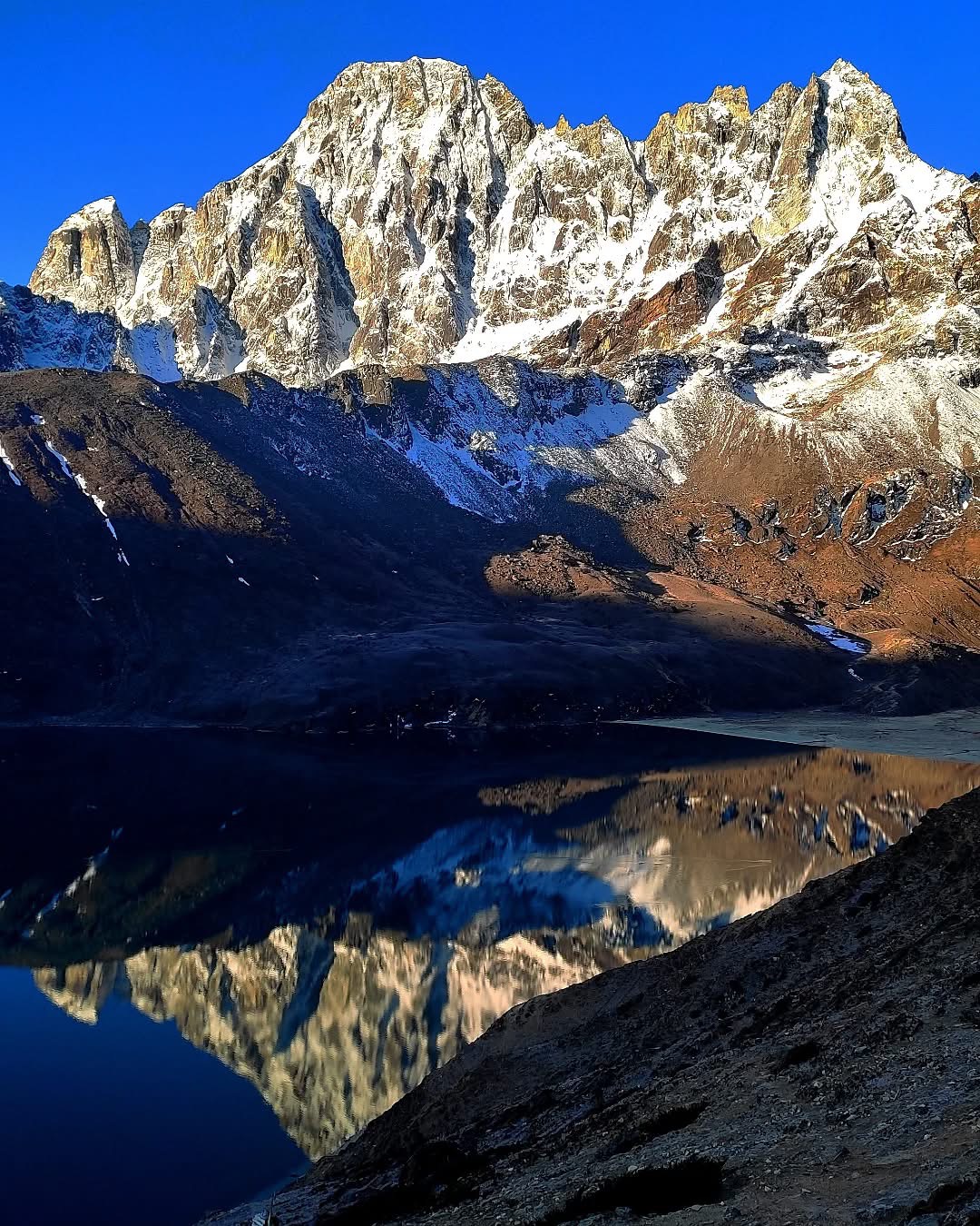
The Gokyo Valley is the quieter, less-visited side of the Khumbu region, and many experienced trekkers consider it the most beautiful. The Gokyo Lakes are a series of six sacred glacial lakes at altitudes between 4,700 and 5,000 meters, their water an intense turquoise-blue against the grey moraine of the Ngozumpa Glacier, which is the largest glacier in Nepal. The climb to Gokyo Ri at 5,357 meters gives a panoramic view of Everest, Cho Oyu, Lhotse, and Makalu all at the same time, four of the world's fourteen eight-thousanders in a single frame. Many experienced trekkers rate this view above the one from Kala Patthar. The Gokyo Valley has a different quality from the main Everest Base Camp trail. It is quieter, the landscape is wider, and the glacier and lake combination is something that the standard route does not offer.
ITINERARY
Days
From
Destination
Distance
Duration
Day-1
Internatoinal country
Kathmandu Nepal (1335m) (HeartilyWelcome)
Day-2
Kathmandu Valley
Trekking Shopping at Kathmandu
Day-3
Kathmandu (1335m)
Lukla (2843m)-Phakding (2610m)
7.8 km.
35min fly + 3 hrs
Day-4
Phakding (2610m)
Namche (3440m)
10.7 km.
7 hrs
Day-5
Namche (3440m)
Acclimatisation day
Day-6
Namche (3440m)
Dole (4200m)
11.4 km.
5 hrs
Day-7
Dole (4200m)
Machhermo (4470m)
5.3 km.
2:30 hrs
Day-8
Machhermo (4470m)
Acclimatisation day
Day-9
Machhermo (4470m)
Gokyo (4790m)-
7 km.
3 hrs
Day-10
Gokyo (4790m)
Gokyo Ri(5360m)-Machhermo(4470m)
10.3 km.
6:30 hrs
Day-11
Machhermo (4470m)
Khumjung (3790m)
12.5 km.
5:30 hrs
Day-12
Khumjung (3790m)
Khunde (4840m)-Gonggo hill-Namche (3440m)
7.6 km.
4:30 hrs
Day-13
Namche (3440m)
Phakding (2610m)
10.7 km.
5 hrs
Day-14
Phakding (2610m)
Lukla (2843m)
7.8 km.
3 hrs
Day-15
Lukla (2843m)
Kathmandu (1335m)
35 min flight
Day-16
Kathmandu (1335m)
Visit Kathmandu Valley, Temples, Monastery etc.
Day-17
Kathmandu (1335m)
Safe travels back home! …See you soon!
Detailed Itinerary
Day 1: Arrival in Kathmandu (1,400 m)
You arrive at Tribhuvan International Airport and our team meets you at the gate. After the transfer to your hotel in Thamel, the evening is free. This is a long and demanding trek and the best start is a proper rest. Thamel has excellent restaurants and is a pleasant place to spend a first evening in Nepal.
Day 2: Briefing and Trip Preparation in Kathmandu (1,400 m)
Full trek briefing at the Friendship Trekking office. Your lead guide will take you through the complete 18-day route with particular attention to the Cho La Pass crossing and acclimatization plan. Permits are sorted and gear is checked. The afternoon is free for Kathmandu sightseeing.
Day 3: Flight to Lukla, Trek to Phakding (2,610 m)
The early morning flight to Tenzing-Hillary Airport in Lukla is one of the most dramatic short flights in the world. From the airstrip the trail drops gently through pine forest and over several suspension bridges to Phakding. It is a three to four hour walk and a gentle introduction to the Khumbu.
Day 4: Phakding to Namche Bazaar (3,440 m)
The trail follows the Dudh Koshi valley north, enters Sagarmatha National Park at Monjo, and makes the steep final climb to Namche Bazaar. The moment Everest appears above the ridgeline before Namche is one of the great views on the trek.
Day 5: Acclimatization Day in Namche Bazaar (3,440 m)
A morning hike to the Everest View Hotel ridge at around 3,880 meters gives outstanding panoramic views of Everest, Lhotse, Nuptse, Ama Dablam, and the full Khumbu range. The afternoon is free to explore Namche and its market, museum, and restaurants.
Day 6: Namche Bazaar to Dole (4,030 m)
You leave the main Everest Base Camp trail today and head northwest into the Gokyo Valley. The trail climbs to a high ridge with wide mountain views and then descends through Mong Danda to Dole. The Gokyo Valley is noticeably quieter than the main trail. The landscape opens up and the air feels different.
Day 7: Dole to Machhermo (4,470 m)
A steady climb through increasingly high-alpine terrain. The Ngozumpa Glacier becomes visible on the western side of the valley. Machhermo is a small, remote-feeling settlement with basic lodges and a very clear sky at night. Sleep well and drink plenty of water.
Day 8: Machhermo to Gokyo (4,750 m)
The trail passes the first two Gokyo lakes before reaching Gokyo village beside the third and largest lake, Dudh Pokhari. The water is an intense turquoise blue against the grey of the Ngozumpa Glacier moraine. Gokyo is a genuinely beautiful place. The Gokyo peaks rise sharply on the far side of the valley and the light in the late afternoon is extraordinary.
Day 9: Acclimatization Day in Gokyo, Optional Gokyo Ri Hike (4,750 m / 5,357 m)
The optional hike to Gokyo Ri at 5,357 meters is one of the finest high-altitude viewpoints available to any trekker in Nepal. The climb takes two to three hours and the view from the top takes in Everest, Cho Oyu, Lhotse, Makalu, Gyachung Kang, and the full length of the Ngozumpa Glacier below. Very few places on earth offer a comparable mountain panorama. The afternoon in Gokyo is yours to rest, explore the upper lakes, or simply sit with the view.
8 Days | Maximum Altitude: 3,210 m | Easy to Moderate
Introduction
Poon Hill sits at 3,210 meters in the Annapurna foothills and has long been known for something that very few viewpoints anywhere in the Himalayas can offer: a single panorama that takes in the full Annapurna range, Dhaulagiri at 8,167 meters, Tukuche Peak, Nilgiri, and the iconic fish-tail summit of Machhapuchhre all at once. Sunrise from the hill is one of the most celebrated mountain experiences in all of Nepal, and for good reason. When the first light comes over the eastern horizon and catches the Annapurna peaks one by one, turning the snow from silver to gold, it is the kind of thing that people travel specifically to see and then find themselves unable to properly describe afterward.
The Ghorepani Poon Hill Trek is the most popular short trek in Nepal and the most accessible route into genuine Himalayan Mountain country. The trail passes through the traditional villages of the Magar and Gurung people who have farmed and herded these hillsides for generations. Ghorepani, Tadapani, and Ghandruk are all established Gurung settlements with slate-roofed stone houses, prayer wheels, and a warm and unhurried way of life that makes the mid-hill villages of the Annapurna region some of the most pleasant places to spend a night on any trek in Nepal. The rhododendron forests between Tikhedhungaand Ghorepani are magnificent in spring when the trees are in full bloom. The national bird of Nepal, the Danphe or Himalayan Monal pheasant, is commonly spotted along these forested sections. This is an ideal trek for families with older children, first-time trekkers, those with limited time, and anyone who wants to experience world-class mountain scenery without committing to a long, high-altitude expedition.
Trip Details
Duration: 8 Days
Maximum Altitude: 3,210 m (Poon Hill)
Difficulty Level: Easy to Moderate
Best Season: March to May and September to November
Start Point: Kathmandu
End Point: Pokhara to Kathmandu
Trek Style: Tea House Trek
Average Walking Hours: 3 to 5 hours per day
Trek Region: Annapurna Conservation Area, Gandaki Province
Major Highlights
• Sunrise from Poon Hill: The 45-minute pre-dawn climb to Poon Hill and watching the sun come up over the Annapurna range is one of the most famous sunrise moments in Himalayan trekking. The view covers Annapurna I, Annapurna South, Dhaulagiri, Tukuche, Nilgiri, and Machhapuchhre and is best experienced in the cold, clear air of an autumn or spring morning.
• Gurung Village Culture and Ghandruk: Ghandruk is one of the most beautifully maintained traditional villages in Nepal. Its stone lanes, traditional architecture, and direct views of Annapurna South and Machhapuchhre make it the highlight of the lower section of the trek. The Gurung culture and hospitality here are something that many trekkers say they remember long after the mountain views.
• Rhododendron Forest Walking: The forest trail from Tikhedhunga up to Ghorepani passes through one of the finest rhododendron forests in the Annapurna region. In spring the hillsides are covered in blooms of deep red, pink, and white. The forest is also home to an excellent variety of birds including the Himalayan Monal and several species of laughingthrush.
Brief Itinerary
Day
Route
Elevation
Overnight
1
Arrival in Kathmandu
1,400 m
Kathmandu
2
Drive to Nayapul, Trek to Tikhedhunga
1,540 m
Tikhedhunga
3
Tikhedhunga to Ghorepani
2,850 m
Ghorepani
4
Early Hike to Poon Hill, Trek to Tadapani
3,210 m / 2,630 m
Tadapani
5
Tadapani to Ghandruk, Drive to Pokhara
2,010 m / 820 m
Pokhara
6
Pokhara sightseeing
820 m
Pokhara
7
Flight to Kathmandu
1,400 m
Kathmandu
8
International Departure
1,400 m
Kathmandu
Detailed Itinerary
Day 1: Arrival in Kathmandu (1,400 m)
Our team meets you at Tribhuvan International Airport and transfers you to your hotel in Thamel. The evening is free. This is a short trek with no altitude concerns, so the first evening is simply about settling in, having a good meal, and resting. Your guide will visit the hotel in the evening to introduce themselves, go over the itinerary, and answer any questions before departure tomorrow morning.
Day 2: Drive to Nayapul, Trek to Tikhedhunga (1,540 m)
An early start from Kathmandu for the drive to Pokhara and then on to the trail starting point at Nayapul. The total drive takes around six to seven hours depending on traffic out of Kathmandu. From Nayapul the trail begins along the BhurungdiKhola river through terraced farmland and riverbank forest. It is a gentle, pleasant afternoon walk of around two to three hours with good views of the lower Annapurna foothills. Tikhedhungais a small village where several tea houses sit at the base of the famous stone staircase that tomorrow's climbing will follow.
Day 3: Tikhedhunga to Ghorepani (2,850 m)
Today's walk is the most physically demanding of the trek. From Tikhedhunga the trail climbs thousands of stone steps through rhododendron forest to Ulleri, a hilltop village with fine views back down the valley. Above Ulleri the trail continues to climb through increasingly dense and beautiful forest, passing Nangethanti and Banthanti before finally reaching Ghorepani on its ridge. The climb takes around five to six hours and gains significant elevation. In spring the forest along this section is extraordinary, with rhododendron trees in full bloom and birds calling through the canopy. The effort of today is what earns tomorrow's sunrise.
Day 4: Early Hike to Poon Hill, Trek to Tadapani (3,210 m / 2,630 m)
You leave Ghorepani before sunrise, around 5 in the morning, for the 45-minute climb to Poon Hill. The path is well-worn and other trekkers heading up with torches in the darkness make you feel part of something. At the top, the view opens in every direction. Annapurna I, Annapurna South, Dhaulagiri, TukuchePeak, Nilgiri, Baraha Shikhar, and Machhapuchhre all fill the horizon. As the sun rises, each peak catches the light in turn. The sky turns from dark blue to orange to bright gold. It is the most photographed moment on any Nepal short trek and it earns every bit of that reputation. After spending time on the summit, you return to Ghorepani for breakfast and then take the eastern trail through more forest to Tadapani.
Day 5: Tadapani to Ghandruk, Drive to Pokhara(2,010 m / 820 m)
The morning walk from Tadapani descends through beautiful mixed forest to the Gurung village of Ghandruk. The village is one of the most visited in the Annapurna region and fully deserves it. Its stone-paved lanes, traditional houses, and direct views of Annapurna South and Machhapuchhre across the valley make it a very special place to spend a morning. Visit the Gurung museum if it is open and take a walk through the upper part of the village for the best views. After lunch, a jeep carries you down to Nayapul and then on to Pokhara. The lakeside city in the evening is a wonderful final note after four days in the hills.
Day 6: Pokhara sightseeing, Paragliding
Day 7: Flight to Kathmandu (1,400 m)
A short 25-minute flight from Pokhara back to Kathmandu. You can also take the tourist bus if you prefer the road journey, which takes around seven hours. The afternoon in Kathmandu is free for any last shopping or sightseeing. In the evening, the Friendship Trekking team joins you for a farewell dinner in Thamel.
Day 8: International Departure (1,400 m)
Our team transfers you to the airport for your international flight home. The Ghorepani Poon Hill Trek is short but it is full. The forests, the villages, the faces of the guides and people you met on the trail, and that sunrise from Poon Hill. These are the things that stay. Thank you for choosing Friendship Trekking.

.jpg)


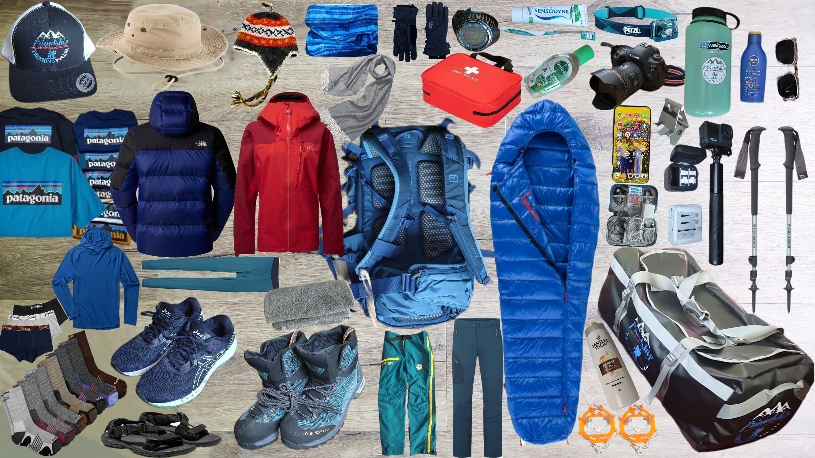 What we needs for our trekking.
 Most important tips for altitude trekkers.


.png)
