Annapurna Circuit Trek altitude 5,416m. (19 Days)

DELUXE LUXURY PACKAGE
     • Private airport transfers throughout
     • 5-star hotel in Kathmandu on bed and breakfast basis
     • Best available lodge accommodation on the trek with private rooms and attached bathrooms where available
     • All meals during the trek (breakfast, lunch, and dinner)
     • Kathmandu to your trekking start point and aftrer trekking ending point to Kathmandu by helicopter
     • Dedicated private guide (one guide per trekker)
     • Private porter for each trekker
     • National Park entry permit
     • Comprehensive first aid and emergency kit
     • Guide, porter, and staff wages, meals, insurance, and equipment
     • Welcome and farewell dinners at premium restaurant in Kathmandu
     • Duffle bag, downjacket, sleeping bag, trekking poles and trekking map

	Price $4650
STANDARD PACKAGE
    • Airport pickups and drops in  Kathmandu
    • 4-star hotel in Kathmandu on bed and breakfast basis
    • Good standard tea house accommodation with private rooms where available
    • All meals during the trek (breakfast, lunch, and dinner)
    • Domestic flight
    • Senior licensed English-speaking trekking guide
    • Porter service (1 porter for every 2 trekkers)
    • National Park entry permit
    • Comprehensive first aid kit
    • Guide, porter, and staff wages, meals, insurance, and equipment
    • Farewell dinner in Kathmandu
    • Duffle bag, downjacket, sleeping bag, trekking poles and trekking map
		Price $2850
ECONOMY PACKAGE
    • Airport pickups and drops in Kathmandu
    • 3-star hotel in Kathmandu on bed and breakfast basis
    • Basic tea house accommodation on the trek (shared rooms where necessary)
    • All meals during the trek (breakfast, lunch, and dinner)
    • Domestic flight
    • Licensed English-speaking trekking guide
    • Porter service (1 porter for every 2 trekkers)
    • National Park entry permit
    • First aid kit
    • Guide, porter, and staff wages, meals, insurance, and equipment
    • Farewell dinner in Kathmandu
    • Duffle bag and trekking map
		Price $1650
Annapurna Circuit Trek
19 Days | Maximum Altitude: 5,416m. | Moderate to Challenging
Introduction
The Annapurna Conservation Area is the largest protected region in Nepal and the Annapurna Circuit passes through the full breadth of it. This trek is celebrated not just for its mountain scenery but for the extraordinary variety of everything it offers. You begin your trek in the humid subtropical lowlands of the Marsyangdi valley, trek through the terraced rice fields and villages of Lamjung district, climb into the high semi-arid landscape of the Manang valley, and cross the Thorong La Pass at 5,416 meters, one of the highest trekking passes in the world. On the far side everything changes. You descend into the ancient Tibetan-influenced world of upper Mustang, where eroded cliffs, cave dwellings, and whitewashed chortens line a landscape that looks and feels completely different from anything you have trekked through to reach it.l
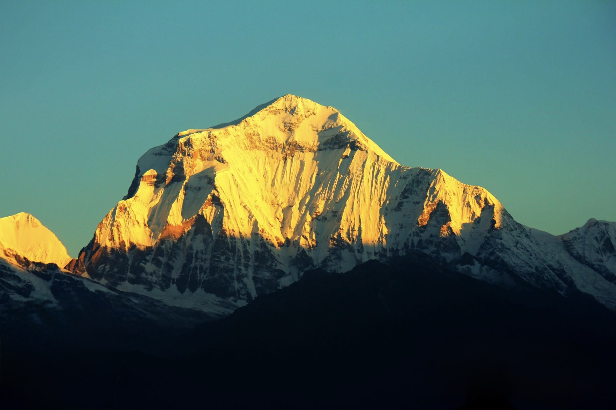
The people of this route are as varied as the terrain. In the lower valleys you pass through communities of the Gurung, Magar, and Brahmin people. As you gain altitude, the villages become increasingly Tibetan Buddhist in character. Manang and the villages of upper Mustang follow Tibetan customs, speak Tibetan dialects, and maintain a culture that has changed very little over centuries. The Muktinath temple is one of the most sacred sites in both Hindu and Buddhist traditions. Pilgrims travel from all over Nepal and India to worship here. The beautiful mountains seen from the circuit include Annapurna I at 8,091 meters, Dhaulagiri at 8,167 meters, Manaslu at 8,163 meters, Machhapuchhre, Nilgiri, Gangapurna, Tilicho, and the full Annapurna massif.
This 18-day route adds the beautiful lower Mustang valleys, the natural hot springs of Tatopani, the rhododendron forests above Ghorepani, and the legendary Poon Hill sunrise before descending through the Gurung village of Ghandruk to Pokhara.
Trip Details
Duration: 18 Days
Maximum Altitude: 5,416 m (Thorong La Pass)
Difficulty Level: Moderate to Challenging
Best Season: March to May and September to November
Start Point: Kathmandu
End Point: Pokhara to Kathmandu
Trek Style: Tea House Trek
Average Walking Hours: 5 to 8 hours per day
Trek Region: Annapurna Conservation Area, Gandaki Province
Major Highlights
• Crossing Thorong La Pass: At 5,416 meters, the Thorong La is one of the highest trekking passes in the world. Crossing it from High Camp in the early morning, reaching the prayer flags at the top, and descending into the completely different world of upper Mustang is the single most dramatic day on any Nepal trekking route.
• Muktinath, Marpha, and the Mustang Valleys: The sacred Muktinath temple, the ancient walled town of Kagbeni, and the beautiful whitewashed apple orchards of Marpha give this extended route a cultural depth that the standard circuit finish in Jomsom cannot match. Adding Tatopani hot springs and the Poon Hill sunrise creates a complete journey through the best of the Annapurna region.
• Poon Hill Sunrise: Standing on Poon Hill at 3,210 meters as the sun comes up over the eastern Himalayan horizon and lights up the Annapurna range, Dhaulagiri, and Machhapuchhre one by one is one of the most celebrated sunrise experiences in all of Nepal. It is a fitting final morning on the mountain section of this trek.
Brief Itinerary
| Day | Route | Elevation | Overnight |
| 1 | Arrival in Kathmandu | 1,400 m | Kathmandu |
| 2 | Briefing and Trip Preparation in Kathmandu | 1,400 m | Kathmandu |
| 3 | Drive from Kathmandu to Besi Sahar | 760 m | Besi Sahar |
| 4 | Drive from Besi Sahar to Chame | 2,670 m | Chame |
| 5 | Chame to Pisang | 3,300 m | Pisang |
| 6 | Pisang to Manang | 3,540 m | Manang |
| 7 | Acclimatization Day in Manang | 3,540 m | Manang |
| 8 | Manang to Yak Kharka | 4,050 m | Yak Kharka |
| 9 | Yak Kharka to Thorong High Camp | 4,925 m | High Camp |
| 10 | High Camp over Thorong La Pass to Muktinath | 5,416 m / 3,760 m | Muktinath |
| 11 | Muktinath to Marpha | 2,670 m | Marpha |
| 12 | Marpha to Tatopani (by Vehicle) | 1,190 m | Tatopani |
| 13 | Tatopani to Ghorepani | 2,874 m | Ghorepani |
| 14 | Early Morning Poon Hill Sunrise, Trek to Tadapani | 3,210 m / 2,630 m | Tadapani |
| 15 | Tadapani to Ghandruk | 1,940 m | Ghandruk |
| 16 | Ghandruk to Pokhara | 820 m | Pokhara |
| 17 | Pokhara sightseeing | 820 m | Pokhara |
| 18 | Pokhara to Kathmandu | 1,400 m | Kathmandu |
| 19 | International Departure | 1,400 | Kathmandu |
Detailed Itinerary
Day 1: Arrival in Kathmandu (1,400 m)
You arrive at Tribhuvan International Airport and our team is waiting at the arrival gate. After the transfer to your hotel in Thamel, the evening is yours to settle in, have a good meal, and get a proper rest. Kathmandu is always a stimulating first night, but an early sleep before the days ahead is the right call.
Day 2: Briefing and Trip Preparation in Kathmandu(1,400 m)
We meet at the Friendship Trekking office for a full briefing on the complete 18-day route. Your guide will walk you through every stage of the trek, explain the altitude and acclimatization plan, and make sure your gear is sorted. Permits are arranged today. The afternoon is free for sightseeing in Kathmandu. Boudhanath, Pashupatinath, and the old city of Patan are all close by and worth visiting before you leave for the hills.
Day 3: Drive from Kathmandu to Besi Sahar (760 m)
After breakfast we leave Kathmandu in a private vehicle. The drive to Besi Sahar follows the Prithvi Highway west before turning north into the Marsyangdi valley. The journey takes around five to six hours through market towns, river valleys, and agricultural land that gets greener and narrower as you go. Besi Sahar is the jumping-off point for the Annapurna Circuit and the last proper town you will see for some days.
Day 4: Drive from Besi Sahar to Chame(2,670 m)
A jeep or local vehicle carries you up through the lower Marsyangdi valley to Chame, the headquarters of Manang district. The drive takes around four to five hours through the deep gorge above Dharapani, passing through Bhulbhule, Ngadi, and Bagarchhap. The road is dramatic and the valley walls grow taller as you go. Chame itself is a proper small town with good tea houses, a police checkpoint, and your first close-up views of the major Annapurna peaks appearing above the valley ridges.
Day 5: Chame to Pisang (3,300 m)
Today the walking begins in earnest. The trail follows the Marsyangdi River north through dense pine forest with LamjungHimal and Annapurna II providing increasingly dramatic company. You pass through Bhratang and enter a long-curvedrock wall that channels the river through a narrow canyon. After crossing the bridge, the valley opens into a broad flat plain and you reach Pisang with its ancient watchtower and a small monastery on the ridge above the village. The high route via Upper Pisang gives outstanding early views of the Annapurna range and is worth the extra climb if your legs are willing.
Day 6: Pisang to Manang (3,540 m)
One of the finest walking days of the entire circuit. From Pisang you can take the high route through Ghyaru and Ngawal, which runs along a high ridge with spectacular mountain panoramas every step of the way. The lower valley route is shorter but far less scenic. Both routes converge at Braga, a remarkable medieval village of stacked stone houses built directly into a cliff face with a centuries-old monastery above it. From Braga it is a short walk to Manang, the largest town in the high valley and a well-supplied base before the pass crossing.
Day 7: Acclimatization Day in Manang (3,540 m)
This acclimatization day is not optional. The Thorong La Pass is at 5,416 meters and Manang at 3,540 is a critical conditioning stop. We recommend hiking up to Gangapurna Lake at around 3,900 meters or continuing to Ice Lake at approximately 4,600 meters. Both offer excellent high-altitude exercise without overloading the body. In the afternoon, the Himalayan Rescue Association often gives a free altitude sickness talk in Manang which we strongly encourage all trekkers to attend. In the evening, rest early and drink plenty of water.
Day 8: Manang to Yak Kharka (4,050 m)
A shorter but important day. Leaving Manang, the trail climbs steadily through open yak grazing pastures with Annapurna III, Gangapurna, and Tilicho Peak in clear view. The landscape becomes progressively more high-alpine and the air noticeably thinner. Yak Kharka is a small settlement in a wide-open valley. You will very likely see actual yaks on the surrounding hillsides. Drink well, eat a filling dinner, and get an early night. Tomorrow the real climbing begins.
Day 9: Yak Kharka to Thorong High Camp (4,925 m)
A short day in distance but demanding in altitude. The trail climbs continuously from Yak Kharka through Thorong Phedi and then makes a steep final ascent up to High Camp at 4,925 meters. At this altitude every section of uphill takes more time and effort than it would lower down. The wind at High Camp can be significant. Eat well, hydrate constantly, and sleep as soon as possible. You will be woken before 4 in the morning for the pass crossing and an early departure is essential to reach the other side before the afternoon winds pick up.
Day 10: High Camp over Thorong La Pass to Muktinath(5,416 m / 3,760 m)
The biggest and most celebrated day of the trek. You leave High Camp in the dark, usually between 4 and 5 in the morning. The climb to Thorong La takes two to three hours from High Camp, with the final section steep and exposed. Reaching the top at 5,416 meters, surrounded by prayer flags and stone cairns with a vast Himalayan panorama in every direction, is a genuine high point of any Himalayan trekking career. The descent to Muktinath is long, dropping around 1,600 vertical meters, and your knees will feel every metre of it, but the path is clear and the landscape on the Mustang side is completely different from anything you have walked through. The arid cliffs, chortens, and prayer walls feel almost Tibetan. Muktinath at 3,760 meters is one of the most sacred pilgrimage sites in Nepal, revered equally by Hindus and Buddhists. The Vishnu temple and the 108 water spouts are worth visiting before you rest.
Day 11: Muktinath to Marpha(2,670 m)
From Muktinath the trail descends through the extraordinary landscape of upper Mustang. Eroded cliffs in shades of red and ochre line the valley. Ancient cave dwellings punctuate the clifffaces. The walled town of Kagbeni, sitting at the confluence of the Kali Gandaki and Jhong Khola rivers, is one of the most atmospheric places on the route. Its narrow lanes, old monastery, and Tibetan-style architecture make it well worth a long pause. Continuing south along the Kali Gandaki, said to be the deepest river valley in the world, you reach the beautiful whitewashed village of Marpha. Marpha is famous throughout Nepal for its apple orchards and the apple brandy made here. Try some with dinner.
Day 12: Marpha to Tatopani by Vehicle (1,190 m)
Today you take a vehicle south along the Kali Gandaki valley from Marpha to Tatopani. The drive passes through Jomsom, the main town of the Mustang region, and continues through the lower valley past Tukuche, Lete, Kalopani, and Ghasa before arriving at Tatopani. The drive takes around two to three hours. Tatopani means warm water in Nepali and the village lives up to its name. Natural hot spring pools sit by the river, and after the long days of high-altitude walking, soaking in them for the afternoon is a genuine physical pleasure. Your body will thank you.
Day 13: Tatopani to Ghorepani(2,874 m)
One of the steeper climbing days of the trek. From Tatopani at 1,190 meters the trail climbs continuously through forest all the way to Ghorepani at 2,874 meters. The elevation gain is significant and the five-to-six-hour climb requires steady effort. In spring the rhododendron forests along this section are in full bloom, with every shade of red, pink, and white covering the hillsides. It is genuinely beautiful walking even when the legs are working hard. Ghorepani sits on a ridge with views of the Annapurna and Dhaulagiri ranges. Settle in early tonight because tomorrow begins before sunrise.
Day 14: Early Morning Poon Hill Sunrise, Trek to Tadapani(3,210 m / 2,630 m)
You leave Ghorepani around 5 in the morning for the 45-minute climb to Poon Hill at 3,210 meters. The path is well-marked and you will have the company of other trekkers heading up in the darkness. As the sun rises over the eastern horizon, the Annapurna range, Dhaulagiri, Tukuche Peak, Nilgiri, and Machhapuchhre catch the morning light one by one. The panorama covers more than a dozen major Himalayan peaks. It is one of the finest mountain views available to any trekker in Nepal. After spending time on the summit, return to Ghorepanifor breakfast and then take the forest path east to Tadapani.
Day 15: Tadapani to Ghandruk (1,940 m)
A shorter and very pleasant morning walk through forest and open ridgelines brings you to Ghandruk, one of the most beautiful and best-preserved Gurung villages in Nepal. The village sits on a wide hillside terrace with Machhapuchhre and Annapurna South filling the view across the valley. Slate-roofed stone houses, flower-lined stone paths, and a genuine sense of community make Ghandruk a place where it is easy to spend the afternoon slowly. The local Gurung museum is worth visiting and the evening views from the upper part of the village are excellent.
Day 16: Ghandruk to Pokhara (820 m)
The final walking day takes you down from Ghandruk through the lower foothills to Nayapul. The trail drops through Kimcheand several small farming villages with views back up toward the Annapurna peaks the whole way. From Nayapul a drive of around one hour brings you to Pokhara. The city sits on the shore of Phewa Lake with the entire Annapurna range reflected in the water on a clear morning. Check in to your hotel and take the evening slowly. Walk the lakeside, hire a rowboat, or simply sit somewhere and let 16 days of mountain walking settle in you.
Day 17: Pokhara to Kathmandu (1,400 m)
Return to Kathmandu by tourist bus or domestic flight according to your package. The bus takes around seven hours along the Prithvi Highway and offers pleasant valley scenery. The flight takes 25 minutes. On arrival in Kathmandu there is time for any last sightseeing or shopping before the evening farewell dinner.
Day 18: Pokhara sightseeing, paragliding
Day 19 : International Departure(1,400 m)
Our team transfers you to the airport for your international flight. Eighteen days, two completely different mountain worlds, one of the highest trekking passes on earth, ancient pilgrimage temples, apple orchards, hot springs, and a sunrise that very few people forget. Thank you for walking the Annapurna Circuit with Friendship Trekking.
Annapurna Circuit Trek altitude 5,416m. (20 Days)


.png)
